Watershed Restoration and Biotechnical Landslide Repairby Marlene Woodard, Project Coordinator, Salix Applied Earthcare |
 In February and in April of 1997, John McCullah, Certified Professional of Erosion and Sediment Control (CPESC) and owner of Salix Applied Earthcare, was faced with several challenges occurring within two different projects. The first project was in the Paige-Bar watershed, a sub-watershed of Clear Creek in the Whiskeytown National Recreation Area near Redding, California. The second project was located in the Chapman Creek Watershed in Sechelt, British Columbia. Background of Paige-Bar Watershed (Site 1) The Paige-Bar Watershed demonstration project is an ongoing rehabilitation project funded through a grant by the Bureau of Reclamation and approved by the United States Fish & Wildlife Service. The grant is funding Shasta College to repair and construct a 6600 foot segment of road, including the installation of replacement culverts, placing and compacting road base and the installation of a sediment trap as a monitor and sediment control measure. The majority of roads in the upper park watershed are unimproved or paved with gravel. Many of these roads are old abandoned logging roads and are composed of highly erodible material and are ineffectively graded. In steep areas like those found in the upper watershed, large volumes of high-velocity runoff water can seriously erode these roads, cutbanks and fill surfaces. In addition, many road culverts are improperly sized to provide sufficient drainage. The Paige-Bar sub-watershed was determined to be an excellent representative of the entire Whiskeytown National Recreation Area in terms of the effects of human disturbance on the ecosystem. The goal of this demonstration watershed is to minimize erosion caused by past land management activities and to encourage the return of the natural ecosystems to their pretimber harvesting, mining, and road building eras, while providing 'hands on' training for the local Shasta College students.
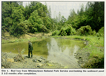
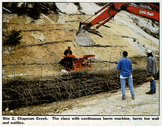
Results Before the project could begin, a sediment trap needed to be constructed for the purpose of providing sediment control measures and future monitoring of sediment runoff. A site was chosen for three reasons: 1) the stream separated into two forks, north and south - therefore the north fork of the stream could be piped into the south fork while constructing the pond; 2) the north fork of the stream passed between two elevated road beds, which could be used as embankments for the pond, minimizing impact; and 3) old road fill would be removed out of the streambed, thereby removing eroding road fill from depositing down stream at some future storm event. After this site was approved of by an archeologist and the Whiskeytown National Park, the class started the design of the sediment trap. A number of sediment trap designs were considered for the project. One option was a soil embankment, drained with a slotted riser. Another possibility was a shallow pool area with silt fence material as the embankment/weir, thereby filtering sediment without a large ponding of water. However, these traps were rejected: if the pipe should plug in the soil weir with the slotted riser, then the soil embankment or the emergency spillway could erode, putting sediment into the creek. The concerns with using the silt fence approach were: 1) silt fences should not be placed directly in a channel; 2) the difficulty of digging a key way in the channel deep enough; and 3) to key in to the bedrock to keep the silt fence in place. Another concern by the park service was to keep the sediment trap aesthetically pleasing and safe for the public. The trap would be built along a high traffic trail area used by hikers, mountain bikers, equestrians, and elementary students from the nearby National Environmental Education Development (NEED) Camp. So the trap design needed to be kept shallow, and if the slotted riser was used, then the depth of the pond would need to be seven feet or greater. John McCullah, in search of a suitable alternative, contacted Ed Taylor from MBW, a manufacturer of the continuous berm machine. Ed offered several solutions for the design of the trap. Because of their resistance to stream erosion, a small weir can be constructed to pass the desired return flow without any additional erosion control structures in the stream. Since the berm conforms tightly to the contours of the land, no trenching or staking is required. The berms would be filled with local gravels, so if the berm did fail, it would only be putting gravels originally from the stream back into the stream. Also, one of the biggest benefits of using the berm would be that willows could be staked into the berm, adding to the aesthetics of the area. On February 5, 1997, an in-stream diversion dike was completed before construction could begin on the sediment trap. Berms for the diversion dike were constructed off-site using MBW's continuous berm machine, Synthetic Industries 501 (or an equivalent Amoco 4551) non-woven geotextile material and filled with native material removed from the streambed. The berms were then transported into position by a backhoe with a spreader bar attached to the bucket. Flexible pipe was installed into the northern fork of the stream with a berm on either side of the pipe. One berm was placed on top to allow the damming of water behind the weir and to divert the northern fork of the stream to the southern fork, therefore draining the construction area. Then two 4-inch through pipes with risers attached were set on the stream gradient where the berm weir was planned to be built. The risers would act as an emergency overflow, and when the risers are removed at the end of the project, they can then drain the pond. On February 10th, a crew of Shasta College's watershed restoration students and heavy equipment students started the clearing of non-native blackberry bushes, transplanting willows and other native vegetation to surrounding undisturbed locations. A backhoe was used to dig a small ponding area to settle sediments stirred up during the construction. The berms for the embankment were constructed with lengths from 5-10 feet to allow for the joints of the adjacent berms to be staggered for strength. The berms were constructed in four layers, with five berms across the bottom layer, followed by four berms on the second layer, three on the third, and three on the fourth. Each successive layer was compacted to approximately 8 inches of height using a plate compactor. Low spots in the berm were leveled using loose soil, which compacted into place and overlain by successive layers of berm to hold it in place. The edge of the continuous berms were allowed to merge with the soil-wrapped berm, which was compacted in lifts and built to the design height of the pond. The total berm length required to close the downstream end of the pond was found to be 53 feet between the two elevated road beds. The continuous berm spillway was located directly over the existing stream bed, and was designed to be 16 feet in total length with 11 feet of it being used for the spillway, and the remaining five feet being merged into a soil berm which spanned the remaining 42 feet. The soil berm was designed to use a soil-wrapping technique which uses folds of filter fabric between lifts of soil to add stability and strength to the berm. After constructing the berm weir, the bottom of the pond was leveled to the stream bed elevation at the base of the weir, and excavated back to the designed boundary. An attempt was made to avoid straight lines or 90 degree angles to give the pond as much of a natural look as possible. Six- to nine-inch riprap was hand-placed on the upstream face of the dam where it might be subjected to erosion from the current. The watershed class then planted willow stakes on both sides of the weir and joint planted among the riprap. Willow wattles were placed around the edge of the pond, to both stabilize the banks and to minimize any visual impacts from the pond. A mixture of native grasses was planted on the top of the berm, and any bare soil was mulched with straw to minimize sheet erosion. The berm weir took two days to construct; however, if this was not a classroom activity, it probably would have required just one day. The completed sediment trap has a surface area of approximately 4500 sq. ft., and an average depth of two feet. It has a three minute hydraulic detention rate for the ten year return flow, and an average trapping efficiency of greater than 60%. An annual or as-needed maintenance is expected to clean out any overload of sediments and/or replacing any damaged berms. This article can be found in its entirety in the July/August '97 issue of Land and Water. |
©2000, 1999, 1998 Land and Water, Inc.