A Vision for the Illinois River?by Michael Reuter |
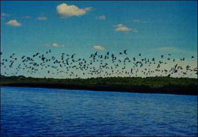 My five-year-old daughter, having read The Wind in the Willows, often asks me whether rivers can talk. An interesting notion. I wonder how the river would respond to a column I read in the Peoria Journal Star. In "Alarmists take note: River trip contradicts some of the eco-disaster myths", the author contrasts the "dreadful doomsday scenes" persistently promulgated by environmental "alarmists" with his observations and reflections made from the deck of a paddlewheel. The author notes evidence of improving water quality and the "proliferation" of certain wildlife populations - including eagles, pelicans and otters - on the Illinois and Mississippi rivers. Indeed, so much attention has been paid to the half-empty glass that we haven't realized it is also half full. In May 1997, another editorial portrayed "the coming crisis as silt fills the bottom of the river". It described "mud flats" and shallow wetlands which developed after Peoria Lakes reached their lowest levels in 15 years, and indicated the river was "choking to death" with "shoots sprouting through water no more than a few inches deep". To boaters, the appearance of these mud flats is indeed alarming. It is also troubling to all of us - farmers and city dwellers - who know the future of our world food supply depends upon whether we can keep fertile black soil on our uplands, where it belongs. But to many plants and animals, this is not a doomsday scene. In fact, at least one of our rarest plants in the Illinois River Valley is a tall and beautiful aster uniquely adapted to growing on freshly exposed mud flats. Many ecologists suggest this "habitat niche" is much rarer now than it was historically - perhaps to the umbrage of a water skier standing knee deep in mud. So. . . what is our vision for the Illinois River? Is it measured by the depth of the water in Peoria Lake on the 4th of July? Or is it the tidiness of the lake, the lack of "ugly" mud flats and "weedy" areas along the shoreline? How important to us are ducks and shorebirds? The unusual paddlefish and native mussels? Would we be happy to stand on Grandview Drive in Peoria 30 years from now and look down upon a diverse complex of islands, small lakes and side channels? This is the portrait nature painted when left to her own devices. Or do we prefer one big lake? One big wetland? The answers to these questions are critically important, for they will tell us whether we encourage mud flats or dredge them out. My experience tells me we must do both! It's important to know that nearly every summer for the past 10,000 years - during the entire lives of some 500 generations of people dwelling in this valley - the river became very shallow. This natural drying period followed similarly predictable spring floods, and preceded much smaller autumn floods. This annual "floodpulse" shaped and sustained an incredible variety of plants and animals, including ancient fish like the paddlefish and sturgeon that are little evolved today from the dinosaur era some 150 million years ago. The floodpulse gave rise to a nearly unparalleled natural abundance of fish, waterfowl, shorebirds, and other wildlife - it was a key reason some 10 percent of the US freshwater commercial fish harvest came out of the Illinois River around the turn of the century. It has only been a half dozen decades - three generations - since it was decided that's not the way we want the river to work. A series of locks and dams were installed on the Illinois and Mississippi, promoting important economic activities such as navigation, but to the exclusion of natural summer drying periods. Half of the floodplain was separated from our river with levees, which prevented flooding of those areas, and in turn, prohibited fish from gaining access to their spawning grounds. The Illinois River was deepened considerably, which created new recreational opportunities for boaters upstream of these dams in the process. But as sediments became trapped behind the dams, alarmingly the river and lakes became more shallow again. Now we're faced with a complex situation - one which even our best ecologists struggle to understand. Is the river simply "rebuilding" its natural floodplain behind these dams, which will lead to the return of islands? Or is sedimentation a dead end, a homogeneous dead zone, as inhospitable to wildlife as to propellers? These are critical questions, because if the first scenario of "rebuilding" is true, it follows that the river - given a chance - can continue to support the rich diversity of life dependent upon it and provide recreational and economic opportunities for generations to come . . . and at much less taxpayer expense than a more intensively managed situation. This richness extends far beyond deer and turkey to plants and animals more sensitive to larger, more dynamic, or higher quality habitats. These species include the aster, as well as the paddlefish, bobcat, prothonotary warbler, and Higgin's-eye mussel. To manage for this natural diversity scenario, we must encourage, perhaps augment, the natural processes of the river, as indicated in the following.
My experience suggests that farmers and townspeople will rise to this challenge together if given good information and freedom to respond in sensible ways. Initiative, and an enduring vision, must come from landowners and local communities, perhaps facilitated by organizations like Tri-County Regional Planning Commission and the Heartland Water Resources Council in Peoria, to be lasting. The Nature Conservancy can help bring forth scientific and socioeconomic information to make sound decisions, and we can play a role in implementation of that vision at a national, as well as local, level. The alternative scenario - the dead zone - is quite dire, as our quality of life and robust economy are heavily dependent upon the health of this river system. But this scenario does not have to come to pass. The Illinois River has proven resilient. It has recovered from earlier periods of high sedimentation, such as during the retreat of glaciers when floodwaters higher than the Murray Baker Bridge roared over the floodplain terraces on which downtown Peoria now rests. Rivers really don't die, but they do change, and they can degrade into something less than what we would consider wonderful. Those who see the glass half full may be aware that in 1992 the National Research Council recognized the Illinois River as one of three large floodplain rivers in the country where ecological recovery was possible, given proper management. The presence of half the floodplain and relatively normal water levels during the year are extremely positive and important indications that the river can respond quickly to changes in management. When my daughter asks me whether rivers can talk, I respond, "Yes, they do, in subtle ways." But I wonder quietly whether people are listening. L&W For more information, contact Michael Reuter, Director of Conservation, The Nature Conservancy of Illinois, 416 Main Street, Suite 1112, Peoria, IL 61602, (309)673-6689, ext. 321, fax (309)673-8986, mreuter@tnc.org. |
©2000, 1999, 1998 Land and Water, Inc.