Greenwood Village Uses Nature's Own Devices to Control Flood Damageby Rob Layton |
| Greenwood Gulch was once natural prairie stream originating in the sandhills southeast of Denver, Colorado, and eventually flowing into the South Platte River. But starting in the 1940's, the effects of a half-century of development in Greenwood Village, a suburban area south of Denver, completely altered Greenwood Gulch.
The stream was channelized, ostensibly to protect adjacent homes against flooding, but the narrower, straighter channel only caused the stream to flow faster. In recent years, urban development in Greenwood Village caused an increase in the speed and volume of runoff and sediments. This cut an eight-foot-deep channel in the middle of Greenwood Gulch, which left two acres of adjacent wetlands high and dry. What remained was a weedy mess (including such thorny invaders as teasel and Canada thistle) even more prone to flooding than before. Greenwood Village assembled a team that included Design Concepts, landscape architects based in Lafayette, Colorado, to find a solution.
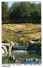
This fall, residents of Greenwood Village began enjoying a restored and expanded wetlands area as well as 4,000 linear feet of improved bike and horse trail along the stream. The innovative design for Greenwood Gulch imitates nature to control the flooding and erosion that had damaged the wetlands and path. Instead of concrete channels with straight lines and an "engineered" look, the stream now meanders through the wetlands. The cattail marshes were expanded from two to six acres and planted with native wildflowers and wetland plants. Wildlife habitat, recreation, and flood control co-exist in this project, which is included in the city's open-space system. The restoration "makes the experience of trail users more enjoyable by bringing them close to water and wetlands and the sound of water," says Chuck McKnight, PE, of Sellards & Grigg, Inc., the Lakewood, Colorado, engineering firm that managed the project. The team also included ecologist Allan Crockett, Ph.D., with Schafer & Associates, Inc. of Golden, who advised on wetlands plants. The construction contract was awarded to R.B.I., Inc. of Denver. Water and Waste Engineering Inc. of Denver were consultants for the City of Greenwood Village and the Urban Drainage and Flood Control District. The construction began by removing and hauling away tons of weedy soil. In the process, the entire stream bed was regraded to simulate the depth and bank structure of a natural stream. Early in the design process, the public was invited to participate in selecting a method to slow the flow of rushing waters during spring rains and summer monsoons. Several options, ranging from a series of small grouted stone structures to large boulder drops, were presented to the community in the form of drawings and illustrations. The residents of Greenwood Village chose the look of a natural waterfall, so several boulders of more than six feet in diameter were muscled into place to create the drops. Two drops were combined at one location to create a dramatic waterfall. Farther downstream, several check dams were added. The check dams cause the water to spread out, creating a broad wetland, and prevent head cutting and gullying. Initially, there was some public resistance to the plan to naturalize Greenwood Gulch. The residents of the two neighborhoods adjoining Greenwood Gulch were particularly concerned that the plan would not address flooding. How, they asked, would making the water channel wider prevent flooding? The idea of spreading the water out across the floodplain rather than containing it in a narrow channel didn't make sense to them. Through numerous public meetings held during the planning and construction phases, the design and engineering team was able to explain that increasing the cross-sectional area of the channel also decreased the flood depth. Neighbors also expressed concern about expanding the original wetlands. Wouldn't that create breeding ground for mosquitoes? Again, the team convinced the public that the design would allow the stream to flow continually, although not too fast, keeping water moving rather than creating stagnant pools. Construction was held up by delays in the 404 Permit process, which were beyond the control of the design team. Although this was ultimately resolved and the Section 404 permit issued, the conflict delayed the project by four months, causing the team to miss the opportunity of planting in the spring. To compensate and keep the Greenwood Gulch project on schedule, the team shifted from a planting plan that relied on seeding to one that emphasized placing plugs and rooted cuttings of sedges and rushes. Root pads of cattails and other marsh plants that had been carefully salvaged during construction were also replanted. The site was divided into five different planting zones. An upland zone was seeded with a mixture of prairie wildflower and native grasses dryland planting. The mesic zone, between the uplands and wetlands, was seeded with a mix that would take advantage of the extra available moisture. The upland and mesic areas each had sub-zones of shrub plantings, which were extensively planted with nursery-grown native trees and shrubs. All told, nearly 140,000 square feet of ground was seeded or planted. The planting plan also provided a screen for neighbors who want to preserve their privacy from those passing on the new bike and equestrian trails. The trail combines an eight-foot-wide bike path with an adjacent crusher-fines equestrian path. The path was rerouted to an upland area and laid over a porous base of graded rock to allow water to percolate beneath the path without causing erosion. The new bike path alignment replaces an at-grade crossing on a busy arterial road with an underpass. Here the path is sunken below the grade of the creek bed (and kept dry by a flood wall/spillway), allowing bikers to view the fast-running creek at eye level. Abstract designs on the bridges and the walls of this lighted underpass suggest the flow of water and the region's layers of sedimentary rock. The $1.4 million project, jointly sponsored by the City of Greenwood Village and the Urban Drainage and Flood Control District, is among the first in the region to combine a flood and erosion control project with a wetlands and parkland restoration project. Greenwood Gulch exemplifies the city's commitment to a policy of preserving floodplains and using them to benefit citizens. The restoration meets these aims "by controlling erosion and enhancing wildlife habitats," says Larry Prehm, Deputy City Manager. It also represents a philosophy of creating multiple benefits from drainageways on the part of the Urban Drainage and Flood Control District. L&W For more information, contact Rob Layton or Linda Anderson, Design Concepts, 211 North Public Road, Suite 200, Lafayette,CO 80026,(303) 664-5301, fax (303) 664-5313, or www.desconla.com |
©2000, 1999, 1998 Land and Water, Inc.