Water Computer Model in Texas Could be Guide for Nationby Mike L. Downey, |
| More than a decade of dedicated work on a water availability computer model by a Texas A&M University civil engineering professor and his students is paying off. The State of Texas is using the computer simulation software program - developed by Dr. Ralph Wurbs and his Texas A&M students - to begin helping manage water use of about 190,000 miles of stream and rivers and nearly 6,000 reservoirs covering three million surface acres. The Water Rights Analysis Package, or WRAP, simulates reservoir-river system management under a priority-based water allocation system.
Water availability models are computer programs that calculate the amount of water in a river basin using hydrologic principles and actual measurements taken at stream gages. Simply put, the model figures how much water Mother Nature has provided and what is legally available to each user. WRAP was developed by Wurbs and his students over the past 10 years, largely funded by the Texas Water Resource Institute (TWRI), part of a national institute network created by the 1964 Water Resources Research Act. TWRI is a special unit of the Texas Agricultural Experiment Station (TAES) at Texas A&M in College Station, Texas. The software, a prime example of university research progressing from idea to implementation, is in the public domain, and free to anyone dealing with water supplies. WRAP is generalized for application in any river basin anywhere, with the required datafiles being generated for that particular river rights system. It performs monthly water volume computations, taking into account stream flows, evaporation and historic hydrology. "The way Texas is dealing with water issues could serve as a model for other states. WRAP could be applied to any river basin anywhere," Wurbs said. "The partnership of state agencies, universities and consulting firms - all using WRAP - provides a decision-support system to get the most important result, enough water for everyone."
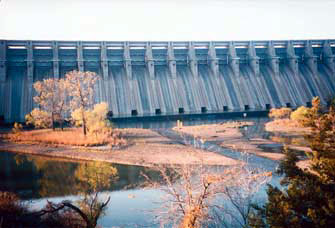
Water has always been a big deal in Texas, despite its reputation for cattle and oil. The coastal city of Corpus Christi just completed building a 101-mile pipeline - big enough to drive a small car through - to Lake Texana to get 15 billion gallons of water a year. Corpus Christi was expecting water shortages as soon as 2002, so the $127 million pipeline was built in only 13 months. The history of water regulation in Texas goes back to Spanish settlers in the state as far back as the 15th century. Even today in the city of San Antonio, a small portion of its acequia (ah-say-key-ah) water system begun by colonizing Spanish missionaries in 1740 still operates through a colonial aqueduct, the only one left in the U.S. Spanish water law required specific authorization to use water. That water law, and later Mexican law, evolved into the concept of "prior appropriation" that contends water rights are separate and apart from land ownership rights. However, in the early 1800s, settlers began using English common law to claim the use of water. Right of use under this water law is based on land ownership. For example, someone who owned land adjacent to a river had the right to fish there or divert water for irrigation. These property-based water rights are called riparian rights, from the Latin for pertaining to a bank. Groundwater was attached to the property above it, so landowners were free to pump like crazy. These dual water laws would continue through modern times. Even today, Texas has no groundwater permits. After 1917, dual water laws - riparian and prior appropriation - continued to overlap since courts upheld individual water rights claimed before the 1889 and 1913 laws. The flaws in this dual system were apparent in 1950 when a seven-year drought in Texas, specifically the southern Lower Rio Grande River Valley, reduced the amount of water so much that water allocated by water rights exceeded the river's supply. In the more recent past - Texas was wrestling with a myriad of problems following the 1996 drought, resulting from increasing demands for water and decreasing availability of water. In 1997, the state legislature passed what's considered by many a milestone in state water management legislation - Senate Bill 1, the Brown-Lewis Water Management Plan - that produced a flurry of activity in organizing state and local agencies to deal with the water issue. In Texas, the state owns the water of public streams and rivers and allows the use of that water by conferring a right, or permit, to use. Water is currently regulated by two state agencies: the Texas Water Development Board and the Texas Natural Resource Conservation Commission (TNRCC). The board is charged with development of a state water plan and also administers state and federal funds to build water supply facilities. The TNRCC issues water rights permits and balances economic and environmental needs of water use. To some degree, the Texas Parks and Wildlife Commission participates in the permit process to protect aquatic habitats and wildlife. A little background - it wasn't until the Irrigation Act of 1889 that Texas formally adopted the principle of "prior appropriation." Essentially, this meant that water use was based on priority: "first in time, first in right." A second central principle was water must be put to beneficial use. This principle of the state's authority to regulate surface water use was extended in 1913 and 1917 as the state legislature amended the 1889 irrigation act. The 1917 amendment created the Texas Board of Water Engineers to oversee state appropriation of water rights. The board was a predecessor to today's Texas Natural Resource Conservation Commission (TNRCC). The 1997 Brown-Lewis law ordered the water development board to create a statewide water plan emphasizing regional planning. The board divided the state into 16 planning regions; a planning group in each region prepares a regional plan for the development, management, and conservation of water resources. All 16 regional groups must turn in their plans by September 1, 2000. The plans become part of the State Water Plan by the year 2001. The new law also charged the TNRCC to begin development of the water availability models for 22 of the state's 23 river basins. Models for the 23rd basin, the Rio Grande, are being developed separately. This $10 million project is for four years. The new models will form a complete modeling system for the state - the Texas Water Availability Modeling System, or WAM. It will include a database of water rights, water uses, streamflows, and other data; Geographic Information System (GIS) tools to analyze streamflows; and the water availability model. The TNRCC went through a complex and arduous process to select WRAP for WAM, despite its use in various Texas river basins since 1987. A TNRCC evaluation team looked at 17 different models ranging from Colorado to the Netherlands before narrowing the choices to four: WRAP from Texas A&M, two from the Danish Hydraulic Institute (including one model that incorporated WRAP), and one from the University of Texas in Austin. Once the WRAP model was selected last summer, all the constituents began using WRAP. "We will continue to polish the model to make it work for every circumstance, but with everyone using the same software, the partnership works better," Wurbs said. One of the basic problems facing any Texas water plan is the nearly-8,000 water rights holders in the state. While about 300 of those have access to most of the state's water, any computer simulation program has to take into account all those water rights - in order of priority-each time any one holder takes any action.
Two basic criteria have to be met as well: ensuring that one holder's action has no adverse impact on the other users and making sure there is enough water available for that action. "Water is an extremely variable resource," Wurbs said. "WRAP has to allocate water to all users based on the priority system." It was just 1967 that the Texas Legislature passed the Water Rights Adjudication Act to create a unified system that merged all claims, Spanish/Mexican grants and riparian rights. The law created court-approved "certificates of adjudication" for water rights, all with exact restrictions on usage, amounts and certain environmental concerns and all based on prior appropriation. After 1969, anyone wanting a water right had to seek a permit from the TNRCC. It took about 20 years to adjudicate the states' water rights. The WRAP program works by starting with the historical hydrology, how much water would have flowed without modern intervention - in this case, the record of river and stream flows covering a period from 1940 to the present. Next, it takes today's water management infrastructure (like reservoirs, pump stations, pipelines and so forth) and practices, allocates water to all users and then it determines reliability in meeting demand. About 300 gaging stations are used to determine the flows for the more than 7,700 users. WRAP adjusts to all the permits and natural water flows- it also considers evaporation and rainfall rates by accessing those databases going back to 1940, Wurbs notes. "Water availability modeling is becoming increasingly important as demands intensify on our limited water resources," Wurbs said. Modeling also helps during droughts to serve as scientific evidence to support any decisions to curtail water use, he added. One of the major future issues that Texas will consider - and WRAP will integrate into its software -is water quality, primarily salinity. Wurbs notes that Texas has no groundwater permit system, but the state is currently starting to address that issue. "As you run out of water, you have to be more precise with your contracts to your users," he said. L&W For more information, contact Dr. Ralph Wurbs, Texas A&M University, Civil Engineering Dept., College Station, Texas 77843-3136, Email: wurbs@tamu.edu |
©2000, 1999, 1998 Land and Water, Inc.