Little Miami River Protected from Major Bank Failure |
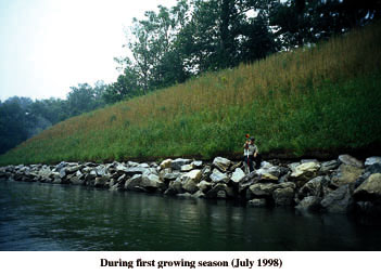
 Running over 100 miles through five counties in Ohio, the Little Miami was designated a Scenic River by the state and federal government in April, 1969. In Hamilton County, the river flows past adjacent Lake Isabella, where an abandoned railroad spur acts as a dike between the lake and the river. Both the river and lake have become a favorite recreation destination for surrounding residents. Composed of mostly fine-grained soils, the dike had been slowly eroded away by the river's hydraulic forces. The county had been battling the erosion for years, when in the early 1990's the problem reached a critical point. The Hamilton County Park District had to act quickly to preserve the integrity of the river and lake, but potential treatments were limited by its designation as a Scenic River and local park district management mandates. Wild and Scenic Designation The Little Miami River qualified as a Scenic River as a result of its free-flowing condition, its mostly undeveloped shoreline, and its many biological and historical attributes. For example, biologists have recorded over 86 fish species, and 36 (including five endangered) mussel species. The Little Miami River embodies the essence of the Wild and Scenic River Act by offering visitors a wealth of quality aquatic and riparian resources, high scenic value, and a rich history. However, restrictions related to its federal and state designation made erosion control and bank stabilization more of a challenge. The Challenge "The Little Miami River is one of the highest quality rivers in Ohio," explains Bob Gable of the Ohio Department of Natural Resources. "The section of the Little Miami River adjacent to Lake Isabella is the habitat for species of fish and fresh water mollusks that are sensitive to sedimentation and habitat alteration." Engineers were faced with the challenge of reconstructing a slope to withstand hydraulic forces associated with 100 year flows of 85,000 cfs, yet still mesh with the area's scenic beauty and biological function. The river's special environmental designation prevented the use of traditional revetments such as concrete, gunnite, gabions, or extensive riprapped banks. Conversely, purely natural alternatives, like vegetative revetments, lacked the durability to endure the river's erosive forces. A Bioengineered Solution "Hydraulic modeling and geotechnical analysis indicated that a bioengineered slope would be the best option given the project's needs," explains Dale Miller, a hydrologist involved with the project. "The final construction included a stone foundation, synthetic cellular confinement layers, natural coir fabric wrapped soil lifts and internal geotextile reinforcement material, all combined with a comprehensive native plant revegetation effort."
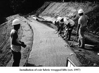
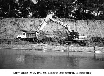
Because analysis showed that erosional (shear) forces decreased progressively upslope from the toe or base of the river bank, the shear resistance of the middle and upper bank treatments were correspondingly reduced. Still, it was a challenge to incorporate native riparian vegetation into mid and upper bank treatments that would withstand expected shear stresses of flood flows on the steep (1.5:1) 30-foot high, outside bend of the river. Large stone riprap, buried deep into the river bed for scour protection, provided a foundation at the toe of the slope (encompassing about 10-15 vertical feet). The use of riprap was originally rejected by regulators in the planning stages because of the unnatural appearance it created, but was deemed necessary at the river bank toe to provide high shear resistance in the zone most effected by the river's flow. The next higher ten vertical foot zone of the bank utilized a perforated Geoweb® cellular confinement system manufactured by Presto Products Company. The concept relies on a synthetic, honeycomb-like structure integrated with a soil fill and plant roots to create an environmentally friendly but rugged bank treatment. Extending ten feet above the cellular confinement section of the slope are 18 inch tall fabric-wrapped soil lifts, or terraces. The river bank's upper-most treatment consists of fabric-covered graded slopes. Both of these upper bank treatments are heavily vegetated to ensure river bank integrity after the biodegradable fabric weakens and decomposes. Construction The face of the 25-30 foot high slope was cleared to remove unstable materials and poorly drained subsoils. To encourage subsurface drainage and eliminate one of the common types of river bank failure, a gravel filter base was installed behind the stone toe foundation upslope to the top of bank. Three bioengineered bank treatments: a cellular confinement system; terraced fabric-wrapped soil lifts; and the graded fabric-covered upper bank were then sequentially constructed. The cellular confinement sections were filled with a mixture of coarse aggregates, topsoil, and slow-release organic fertilizer, then the exposed portion of each cellular confinement section was wrapped in woven coir fabric to prevent soil loss during the initial vegetation establishment phase. New sections were expanded and stacked one on top of the last, set back 1-2 feet to produce the desired slope and to provide exposed horizontal surfaces for grass seed to establish. In addition, the added reinforcement of woody vegetation was provided by inserting 4 foot long rooted willow cuttings, grown by Ernst Conservation, horizontally into custom cut notches in the face of the Geoweb structures. For additional internal bank stability, deeply placed layers of synthetic biaxial fabric layers were incorporated into the bank on specified intervals. The soil lifts were wrapped with a dual layer of woven and non-woven coir fabrics and filled with topsoil. The lifts were seeded and planted with the same rooted willow cuttings, providing the necessary erosion control protection at the 100-year flood level, while appearing very natural from the river. The upper bank treatment was graded to a slope of 1.5:1, and covered with four inches of topsoil, seeded and protected with coir fabric. It should be noted that both of these upper two treatments are true bioengineered treatments, meaning that once the coir fabric degrades, vegetation will ultimately provide the necessary erosion control and river bank protection. The cellular confinement layer is considered a biotechnical treatment in that a combination of synthetic structures and vegetation/soil was used to meet expected shear or erosional forces.
Completion For more information, contact: Todd Hoitsma, Inter-Fluve, Inc. Presto Products Company |
©2000, 1999, 1998 Land and Water, Inc.