Wetland Reservoir Subirrigation Systemsby Barry Allred, Bruce Clevenger, Clifford Thornton, Bernie Czartoski, Norman Fausey, Richard Cooper, Larry Brown, Duane Riethman, Paul Chester and Harold Belcher |
||
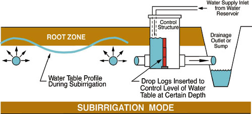 Schematic of weir-type hydraulic control structure used to regulate water table depth in subirrigated fields. (Graphic by Leslie Zucker, Ohio State University Extension) Background
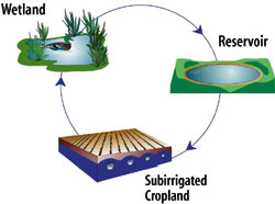
Three WRSIS demonstration sites are now operational within the Ohio portion of the Maumee River Basin, one each in Defiance, Fulton, and Van Wert Counties. The Maumee River Basin encompasses 4.2 million acres and extends across northwest Ohio, northeast Indiana, and southeast Michigan. During the early 1800’s and before settlement, much of this area was known as the “Great Black Swamp”. Major changes began around 1850 with efforts to drain wetland areas for farming. A surface water conveyance channel system was constructed, and tied to networks of underground drain pipe. Almost all of the prior “Great Black Swamp” wetland habitats are now gone, and agricultural crop production accounts for 75 % of overall basin land use. Although one of the most fertile agricultural areas within the U.S. for soybeans, corn, and wheat, this land conversion hasn’t come without significant environmental cost, including increased soil erosion and nonpoint source pollution. The Maumee River empties into Lake Erie, where it discharges over 1.3 million tons of sediment per year. Approximately 500,000 tons of this total amount are deposited in Toledo Harbor alone, requiring the US Army Corps of Engineers to spend $3.4 million dollars in dredging costs annually to keep the shipping channel open. Agricultural practices within the basin also contribute large amounts of nitrate and phosphate nutrients that can impair the aquatic environment in rivers and lakes. By reducing offsite release of agricultural nutrients and sediment, while at the same time enhancing agricultural productivity and restoring wetland habitats, WRSIS can provide a partial solution to environmental problems within the Maumee River Basin that often impact Lake Erie. Project Collaboration and Initial Design Considerations
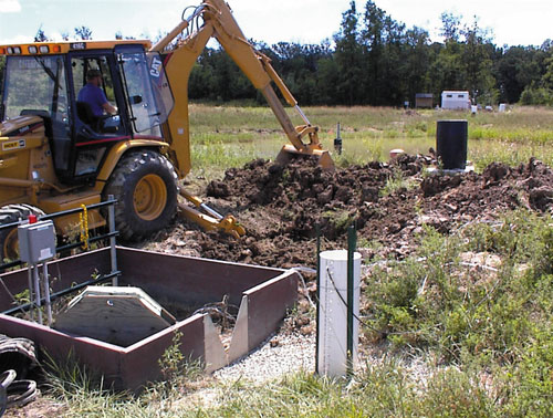
Regarding initial design considerations, all wetlands were built with the capacity to contain the onsite surface runoff and subsurface drainage from approximately 3 inches of rain spread over a 24 hour period. Subirrigation requires a closer spacing between drain lines, often 33 to 50 % of what is typically used for conventional subsurface drainage alone. For this reason, new drain lines installed at both the Fulton and Van Wert County sites were placed between the old ones and then tied into the pre-existing pipe main. Control plot(s) having subsurface pipe for drainage only were included at each site for comparison with crop yields obtained through subirrigation. Subirrigation requirements were established through computer simulation with DRAINMOD, which is used for design and management of agricultural surface and subsurface drainage systems. From this, the size of the storage reservoir at the Defiance County site was determined based on the subirrigation water needed for crops in eight out of every ten years. The existing reservoirs at the other two locations did not meet storage requirements. Through other sources were available which could be tapped, including a groundwater well at the Van Wert County site and a local stream at the Fulton County site. Should the need arise, all three locations were designed with capability for direct offsite release of water from either the wetland or storage reservoir. Although similar in concept, design details differ amongst the three WRSIS locations. Demonstration Site Descriptions Subsurface drain pipe at all three sites was installed at a nominal depth of 3 ft beneath the surface. Half of the seven subirrigated acres at the Defiance County site contain 4-inch diameter corrugated plastic tubing (CPT) drain line spaced 8 feet apart, and the other half has 4-inch diameter CPT drains spaced 16 feet apart. The site is underlain by dense low permeability clay soil that is capable of hindering water transfer from the drain pipe during subirrigation. This in turn makes it difficult to maintain a uniform water table across the field at the optimum depth of 10 inches. Uneven water table depths impact crop yield, which is why two drain spacings were tested. In comparison to the 16-ft spacing, the 8-ft spacing is better adapted for providing consistent ground water levels; but increased crop yields may not be enough to offset the cost of having to install twice the amount of drain pipe. Initially, two hydraulic control structures, one for each subirrigated field, were installed to regulate ground water levels. A wet zone within one of the subirrigated fields required installation of an additional hydraulic control structure in Fall 1999. Capital costs for WRSIS construction at the Defiance County site totaled $44,700.
The Fulton County, Ohio WRSIS was completed by local contractors during Spring 1996 at a total capital cost of $60,000. Corn and soybeans are grown on silty clay soil. The site has two 20-acre fields, one that is subirrigated and the other with drain pipe for subsurface drainage only.
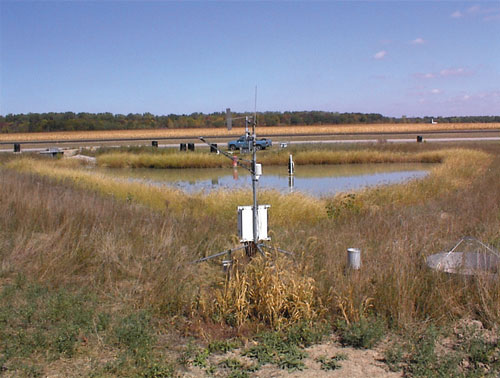
Drain pipes within the subirrigated field are spaced about 15 feet apart, with two newer 4-inch diameter CPT lines placed between each of the older ones (comprised of 4-inch diameter clay tile). The control plot contains only the clay tile lines and the spacing is 45 feet. To regulate the subirrigated field water table depths, three hydraulic control structures were installed. Surface and subsurface drainage from both fields are routed by gravity to a 1.4-acre wetland having a storage capacity of 1.0 million gallons. Water transfer between the wetland and a 1.57-acre, 2.3-million gal capacity reservoir occurs via a 2-hp or a 5-hp submersible pump, both located within an adjacent concrete sump. Either pump can be used when the system is in subirrigation mode. Local contractors completed Van Wert County, Ohio WRSIS construction in Fall 1996 at a total capital cost of $86,300. This site has silty clay soil covering three 15-acre fields: two that are subirrigated; and one with buried pipe used for subsurface drainage only. Surface and subsurface drainage from all 45 acres of corn and soybean cropland are routed, via two 1.5-hp submersible pumps contained in a concrete sump: to either a 1.95 acre, 2.3 million-gal capacity wetland; or a 3.0 acre, 3.4 million-gal capacity reservoir. A 1-hp submersible pump, also located in the concrete sump, is used for subirrigation. Drain lines within the two subirrigated fields have a spacing separation of 17.5 ft, and older 4-inch diameter clay tile pipe alternates with newer 4-inch diameter CPT. The control plot has only the clay tile drain lines, which are spaced 35 feet apart. Initially, two hydraulic control structures, one for each subirrigated field, were installed to regulate shallow ground water levels. However, like the Defiance County site, a wet zone within one of the subirrigated fields necessitated emplacement of an additional hydraulic control structure in Spring 1999. A shallow earth embankment attached to one side of the wetland was built during Summer 1999 to increase the residence time of water flowing from the inlet to the outlet. By doing this, wetland effectiveness for water treatment is improved.
Preliminary Results and Present Research Focus Subirrigation, especially in dry years, can increase average annual crop yields over what normally can be obtained in fields with buried pipe used for subsurface drainage only. This has indeed been the case at the Fulton County site from 1996 through 1999, where subirrigation has resulted in an average 44 bushels/acre increase for corn and a 10.4 bushels/acre increase for soybeans. At the Van Wert County location in 1997 and 1998, subirrigation provided no advantage, largely for two reasons. First, in 1997 and 1998, the site received normal or even above normal rainfall, and therefore subirrigation was minimal. Second, a wet zone within one of the subirrigated fields resulted in crop damage. With installation of an additional hydraulic control structure in Spring 1999 to solve the wet zone problem, subirrigation during that extremely dry year produced a 33 bushels/acre increase for corn and a 12.8 bushels/acre increase for soybeans. Complete comparison records for crop yields between subirrigated and subsurface drained only fields at the Defiance County site are available for just two years. In 1997, subirrigation affected a 26 bushels/acre increase for corn, and in 1999, increases of 16 bushels/acre for corn and 12.9 bushels/acre for soybeans were observed at the Defiance County location. Like the Van Wert County site, these yield numbers will undoubtedly improve due to an added hydraulic control structure installed in Fall 1999 to remove a wet zone in one of the subirrigated fields. Additionally, site management at all locations has been a learning process, and as operators gain more experience with the system, subirrigated crop yields are expected to improve on this basis alone. Present focus is on an extensive monitoring study implemented to evaluate and improve the hydraulic and environmental performance of WRSIS. All monitoring equipment, including water samplers, piezometers, flumes, flow sensors, weather station, etc., have been purchased and are now in place or scheduled for installation by end of Summer 2000. Data collected through monitoring of WRSIS components will be invaluable in assessing benefits, determining the best operation and management strategies, gauging economic viability, and establishing overall environmental impact of a number of such systems within a larger watershed scale. Conclusions For more information, contact Barry Allred, USDA-ARS Soil Drainage Research Unit, 590 Woody Hayes Drive, RM. 234, Columbus, Ohio 43210; (614)292-9806, fax (614)292-9448, allred.13@osu.edu. |
©2000, 1999, 1998 Land and Water, Inc.