Snake River Gravel Pit Project |
|
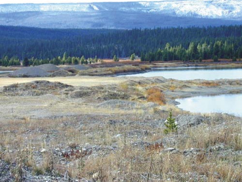
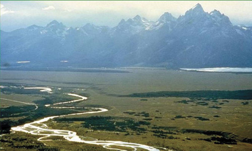
In August 2001, PHC Reclamation, Inc. (PHCREC) was contracted by the State of Wyoming’s Abandoned Land Mine Program (AML) to evaluate and eliminate the public safety hazards and environmental degradation associated with sixty-five acres of land previously disturbed by gravel mining activities. This project was called the Snake River Gravel Pit Project. It is located within the John D. Rockefeller, Jr. Memorial Parkway, approximately two miles south of the Yellowstone National Park south entrance. The site is adjacent to and visi-ble from U. S. Highway 89/287, a main corridor to the South Entrance of Yellowstone. In 1988, a forest fire within the Grand Teton and Yellowstone National Parks burned most of the lodgepole pines that previously had obscured the site from view. Gravel mining within the Snake River Floodplain had created four large pits, several small pits, stockpiles, waste piles and debris dumps. There was little native vegetation on site, but there was abundant exotic vegetation that had estab-lished on the disturbed areas. The first phase of the project was to determine eligibility for AML funding. The site was investigated for eligibility based upon the dates of mine related dis-turbance. The dates of disturbance were determined by an extensive review of available Grand Teton National Park, Region VIII EPA, Cheyenne Regulatory Office and USDA Forest Service records. These records included aerial photo-graphs, published documents and written correspondence. It was concluded that the total area disturbed by mine develop-ment was approximately 64.33 acres. Of the total acres disturbed, 32.24 acres or 50.12% represented pre-law disturbance and 32.09 acres or 49.88% represented post-law disturbance. The entire project site was located within the Yellowstone Grizzly Bear Recovery Area and was designated as a Management Situation I area. Management Situation I areas contain grizzly population centers and habitat components needed for the survival of the species. In addition to being a Grizzly Bear Recovery Area, it had seven species of concern within the project area that were either protected by the Endangered Species Act or were under consideration of such protection. The species included: one endangered species (whooping crane); Three threatened species (bald eagle, grizzly bear, and Ute ladies’-tresses); one experimental population (gray wolf); one species proposed as threatened (mountain plover); and one species that is a candidate for listing (western boreal toad).
The Greater Yellowstone Ecosystem Amphibian Project (GYEAP) refers informally to monitoring and research efforts on the part of the Herpetology Laboratory at Idaho State University (ISU) in conjunction with a wide variety of partners. Western Boreal Toads were documented breeding and developing in Mine Pit 1 by members of the GYEAP in 1997. In addition, adult toads were observed along the western edge of Mine Pit 3. It was determined that the adult toads were also breeding in the undis-turbed adjacent wetlands and utilized the upland communities just south of the project area. The studies by members of the GYEAP determined that adult toads were laying their eggs in the shallow pit waters from March through May. Egg masses were present in the project area through July, tadpoles through August, and young toads through early September.
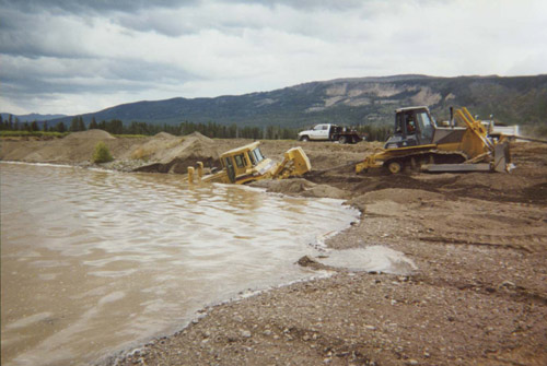
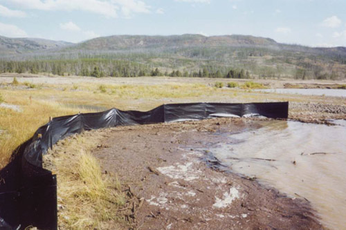
The proposed actions to reclaim the site and restore wetlands were necessary to improve habitat values and to comply with the National Park Service policies that required that the final designs con-sider potential impacts to the species within the project. The actions had to comply with the Standards and Directives of the Clean Water Act in accordance with the U. S. Army Corp of Engineers, the Environmental Protection Agency and the Wyoming Department of Environmental Quality. A combined $1.3 million was received from a partnership between the Federal Highways Administration (Western Federal Lands Highway Division) and the AML in order to complete the investigation, design and reclamation of this project. Special factors that had to be addressed during the design phase includ-ed the complex hydrology of the site, the need to protect existing western boreal toad breeding habitat and appropriate use of topsoil that had been preserved during the mining process. To develop the designs that would be used at the Snake River Gravel Pit Project, several things had to first be addressed. PHCREC utilized the water table data from June 2000, provided by the National Park Service, to develop the proposed contours and grading plan. The water table elevations were measured from the top of each well casing and con-verted into an AutoCAD grid for develop-ment of the proposed contours. Each of theses contours had to be adjusted at their respective end points to "tie into" an existing ground elevation. In addition, every possible attempt was made to place the proposed ponds within each pit at the locations that were indicated by the National Park Service's conceptual design. While creating the final design there were four mini plant environments that had to be developed using the June Piezometric surface. They include:. Lower Herbaceous Zone at -1.3 to -0.1; Herbaceous Zone at -01 to .07; Willow Zone at 0.7 to 1.5 feet; Upland Zone at 1.5 and above. A unique aspect of the design was the use of field experiments to determine which herbaceous plant species would be used and to evaluate the potential for willow establishment from natural seed dispersal. Designing the site to promote survivability of herbaceous plant species and natural willow establishment was a primary goal of the project. Willow seed traps were constructed on-site that allowed monitors to evaluate distribution and abundance of seed dispersal across the site. In early 2002, project participants produced final design drawings and spec-ifications for the construction bid docu-ments specific to Phase 1 (grading) and Phase 2 (agronomics) of the project. CRE, Inc. was selected as the grading contractor and grading activities were performed from mid-July through October 2002. Aquatic & Wetland Planting were selected as the agronomic contractor. Special efforts were undertaken by the project design team to prepare contract specifications and develop recla-mation grading plans that reduced the total impact to the Boreal Toad breeding habitat. Grading work near the eastern portion of Mine Pit 1 was delayed until after the third week of August to ensure the current year’s breeding effort was not destroyed. Erosion control sediment fences and sediment traps were construct-ed along the perimeter of the breeding areas to reduce impacts caused during rain and storm events. Field Orders were prepared and implemented that author-ized the Construction Manger to adjust grading plans within the project area dur-ing construction activities to save existing sparse to moderate stands of short, emer-gent vegetation within Mine Pit Nos. 1 and 3. In addition, the Grand Teton National Park service conducted manda-tory training meetings prior to initiating grading work. These meetings were used to educate the Contractor’s construction crew concerning the sensitive nature of the site. In order to compute cut and fill vol-umes, it was necessary to assign a "top of water" elevation for each pond that coin-cided with the adjacent water table con-tour. An angle of repose for the gravel fill material was calculated from empiri-cal formulas obtained from engineering tables. The bottom of the pond elevations were the actual elevations determined from a 2001 GPS survey. Cut and fill volumes were computed by the pris-moidal method of using SurvCAD soft-ware featuring Carlson Roads and Survey. The volumetric results of the grading plan are as follows: The Department of Environmental Quality (DEQ) considered all waters associated with the Snake River and all of its tributary channels and associated wetlands as Class 1 surface waters. The DEQ concluded that, due to the hydrological connection between the Snake River and the project area by groundwater and potential surface water, any substantial, earth-moving activity with the project area would result in a surface or point source discharge into the Snake River. Therefore, it was necessary for the PHCREC to obtain a DEQ National Pollutant Discharge Elimination System (NPDES) discharge permit and Clean Water Act Section 401, certification prior to performing grading activities. To reduce the impact to the Snake River, the reclamation grading plan included the reshaping of existing inun-dated pits, creation of on-site channels that permit flooding during wet periods, and construction of five (5) on-site ponds. The final alignment and configuration of the ponds were constructed to reduce wave erosion caused by prevailing winds, increase shoreline sinuosity, provide mini-environments for each specific herbaceous plant specie required, and duplicate the pattern of adjacent Snake River oxbows. The project area is located on an alluvial terrace of gravel and cobble within the Snake River floodplain that created stability problems for the contrac-tor’s heavy equipment when performing grading activities adjacent to existing pits. Two areas were specifically designated as "future NPS staging areas" to keep in compliance with the Environmental Assessment (EA) Report prepared by the NPS. Future road proj-ects to be completed in the Park by the FHA would generate approximately 50,000 cubic yards of excess material. It was was requested that the design provide an area to facilitate disposal of this mate-rial. To accommodate this request, Pond No. 5 would not be backfilled as part of the reclamation design. Under the direction of the design team and the onsite Construction Manger, the grading contractor reshaped more than 350,000 cubic yards of mine reject material and topsoil into approximately 55 acres of sedge meadows, willow flats, stream channels, oxbow ponds and upland features.
To ensure revegetation success, a key concept to understand involves the scale of final as-built topographic mapping versus the actual field conditions at the time of planting. Typically on AML projects, final as built mapping contour intervals are 2 feet. For this project, the as-built map was developed using contour intervals of 0.5 feet. For the successful growth of each species of plant, it was critically important whether the planting was at -0.1 or .07 feet above the water table. The NPS requested that the final graded surface be completed in a very rough, uneven condition. The rough sur-face created considerable vertical heterogeneity throughout most of the site. This micro-topographic relief within each planting zone was recognized in the field during the planting activities. Five species of wetland seeds were collected during the summer of 2002 from the nearby Snake River floodplain within 15 km of the Snake River Gravel Pit Project area. The collected seeds were stored at the con-tractor’s native plant nursery located in Ft. Lupton, CO. They were germinated and grown during the winter/spring 2003. Species and quantity of wetland plants grown in 5.7 cubic inch cones included the spike rush (34,500); blister rush (34,500); beaked sedge (176,000); water sedge (200,100); and bluejoint grass (141,500) for a required total of 586,600 plants. Live stem willow cuttings, with buds, were collected from seven species during early May 2003 within the Snake River Floodplain. Stems were prepared measuring 24 inches in length and tem-porarily stored in one of the re-shaped ponds until planted to a depth of 18 inches. Planting of both the herbaceous plugs and willow cuttings began during late May while the ground water table was high and was completed by July 6, 2003, a period of six weeks. The contrac-tor planted approximately 602,000 plants during that span of time.
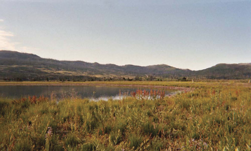
After over a decade since mining activities ceased, the damage to the Snake River Floodplain, wetlands, riparian ecosystem has been reclaimed in accor-dance with NPS management policies, legislative mandates and approved park planning documents. Native herbaceous plants and willows now flourish within the once destroyed floodplain. The Western Boreal Toad is one of the least common amphibians in the Teton-Yellowstone area and its numbers have steadily declined since the 1950’s; in eastern Wyoming and Colorado, it is con-sidered a candidate species by the USFWS. During the summer of 2003, the GYEAP was pleased to find through their continued research efforts that the main toad breeding area had been suc-cessfully protected during extensive reclamation work. The protection efforts are best summarized in the February 2004 correspondence submitted to the Engineer from Dr. Charles R. Peterson, curator of Herpetology, Idaho State University, Idaho Museum of Natural History, “Thank you for incorporating specifications in your work plans and making sure that they were effective. We are aware of no other examples in the Yellowstone-Teton area where construc-tion contractors took such an active interest in amphibians”. The success of the Snake River Gravel Pit Project demonstrates that riparian habitat once damaged and considered lost, can be reclaimed to its original, pristine condition. For excellence in engineering design and construction management services, PHC Reclamation, Inc. (PHCREC) was presented the coveted 2004 People’s Choice Award for the Best National Reclamation Project, by the United States Department of the Interior, Office of Surface Mining for the Snake River Gravel Pit Project. For more information, contact Chris Walla, PE, President, PHC Reclamation, Inc., 7300 Yellowstone Rd., Suite 5, Cheyenne, WY 82009. Phone: 307.634.9845, Fax: 307.634.9827, E-mail: clw@phcreclamation.com. |
©2004 - 1998 Land and Water, Inc.