Redd Rambler Run:
|
|||
|
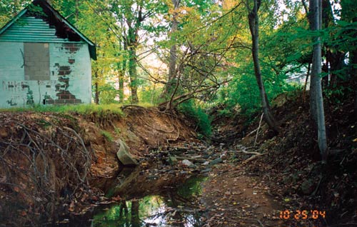
Last year the Philadelphia Water Department (PWD) received calls from a number of concerned homeowners. Each had a specific complaint regarding conditions in their backyards—lost fencing, exposed tree roots, dwindling yard space, exposed pool foundation. All of these complaints originated from a single source—the transformation of their normal flowing backyard stream into a raging torrent of water during storms. Upon inspection, the department discovered widespread erosion that affected not only the callers’ properties, but that of their subdivision at large. After further investigation, PWD began developing plans to launch a pilot project involving the restoration of approximately 2,700 feet of streambed and channel along Redd Rambler Run, whose crumbling banks revealed the decade-long effects of urban development.
The agency felt that in order for the project to succeed, they would need one thing above all—community support. Therefore, as a primary component of the project scope, they included a public involvement initiative aimed at addressing issues with the property owners in an effort to explain the benefits of restoration and the methods they intend to use. The preliminary assessment and design phase of the project culminated with three public meetings last spring. A consensus was reached among the property owners to move ahead with the design phase, which will involve a community open house to address individual impacts to properties. Once the final design is approved, construction will begin. A Pilot ProjectRedd Rambler Run sits within a narrow PWD easement that cuts through approximately 70 backyards in a Philadelphia subdivision. Its problems are typical for an urban stream—channel incision, bank erosion, and blockages to the movement of fish and other aquatic life. According to Joanne Dahme, Watersheds Programs Manager for PWD, the project purpose is to “recreate a stable, aesthetically pleasing stream with the potential to nurture habitat.” It’s a simple goal, but one that entails unique challenges, not the least of which is the channel’s proximity to private homes and the homeowner infrastructure that has encroached upon the stream through the years. “Any work you do on this type of project, you’re going to be working around people,” says Chuck Hegberg, Regional Environmental Manager for KCI Technologies, the firm hired to produce the design plans and lead the public involvement initiative. “The real issue is that you’re working in an urban environment where the property owners are paying high taxes and have limited-sized lots, so they want to know why we can’t just pipe the stream.” In recent years, PWD has adopted a holistic approach to urban stream restoration currently being implemented throughout much of the country. By blending natural science and engineering with an artistic flair, these methods are intended to mimic nature and help the stream maintain itself, while improving water quality and reducing damage caused by fast, heavy flows of stormwater runoff. Although the agency has successfully employed this strategy to restore channels in public parks, they are testing uncharted waters with the Redd Rambler Run. “All of their stream projects have been in park areas,” according to Rich Pfingsten, KCI’s Chief Environmental Scientist. “This is the first time on private property, working within a relatively confined easement.” Mitigation EffortsWhile the stream buffer is wide enough to accommodate the construction equipment necessary for restoration, much of it stretches along the backyards, beyond the easement. Consequently, there’s no way to avoid impacts to private property. This is why the agency wants community support, although they’re under no obligation to obtain it. According to Hegberg, not all municipalities are so friendly. “We’ve worked on projects in other states where the local government basically says, ‘Oh, by the way, we’ll be doing a construction project in your backyard and your fence, shed, tree, etc. is in our easement. Move it or it’s gone.’” PWD is taking a different approach. They want to get buy-in from the community and they’re going to great extremes to accommodate owners.” Aside from facing the obvious inconveniences presented by major backyard construction, some property owners will be faced with various landscape changes such as the removal or relocation of trees, fences or other features of their yards. Moreover, some residents have constructed their own amenities in the PWD right-of-way, such as bridges and retaining walls, which will have to be removed during construction. In short, it’s impossible to fix the stream without affecting the private lots. Nevertheless, Pfingsten says the design team is sensitive to these issues and is working to ensure the right balance. “We’re basically looking at ways to minimize impacts and still get a stable channel. Certain impacts can’t be avoided, but we’re all aware that this is where people live. We don’t want to disturb anything unless it’s really necessary.” “We’re working in urbanized areas with decades of different management ideas,” adds Hegberg—“not open, rural areas. As scientists and engineers, we have to be flexible and experienced enough to use a variety of techniques to reach the goals.” Among these techniques are the shifting of alignments away from existing structures and large trees, the introduction of step-pools to manage channel depth, the narrowing of the channel width for steeper side slopes, the steepening and roughening of the channel bed in localized areas, and the use of imbricated walls along steep embankments, especially around permanent structures. By employing strong mitigation efforts such as these, and by continuing their ongoing dialogue with the community, Dahme says her agency feels confident that property owners will be supportive throughout the project. “We are optimistic that as we review the construction work in greater detail, adjacent property landowners will recognize that the temporary inconvenience of the construction work will be well worth the investment for the end result—a pleasing backyard stream viewed by all the neighbors.” Public InvolvementThe initial phase of the project called for the consultant to undertake three primary tasks: conduct the preliminary stream assessment and engineering in order to determine the necessary channel width for storm flows and normal conditions, conduct a field survey of the channel and the adjacent properties in order to determine what landscape features may require removal or relocation, and prepare the conceptual design plans for an attractive, stable channel, while minimizing the impacts to the private property. As client and consultant discussed their plans, it became evident that, as Pfingsten put it, “We had to stop and turn this into a public involvement project at some point.” This aspect of the project has been viewed primarily as an education initiative. While the property owners can clearly see many of the problems associated with the streambed and channel, the causes and long-term effects of this deterioration are not so evident. Nor are the solutions. By creating a variety of illustrative graphics and other materials to present at a series of public meetings, the project team was able to translate scientific problems and engineering principles into a language accessible to all. Among these materials was a twelve-page brochure introducing the proposed project, including a statement of purpose, a map of the project area, and dozens of photographs detailing not only specific problems with Redd Rambler Run, but also pre- and post-construction conditions of similar urban stream repair projects already successfully completed. These pre- and post-construction photos were also shown in a Powerpoint presentation that included during-construction photos, allowing the audience to get an accurate sense of what they can expect when construction begins. Also on display was a set of 30 x 60 aerial photographs mounted on boards and overlaid with survey data, the preliminary footprint of the stream, and the proposed project limits. Although these boards conveyed relevant project data, their usefulness to the property owners was limited. However, the project team produced one other type of graphic that was, by all accounts, very popular—a three-dimensional, cross sectional (and, to be sure, experimental) graphic referred to as a 3-D cross section. Basically, it’s a hybrid illustration created by laying a CADD cross section over a color photograph. According to Hegberg, the production of these graphics was time-consuming, but well worth the effort. “They were the most difficult part of the public involvement initiative, but a feature that really helped sell the project. They enabled us to show things that we couldn’t have shown any other way.”
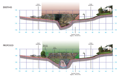
3-D Cross SectionsThe idea came about during a preliminary project meeting in which PWD asked the consultant to produce some kind of landscape drawings to show what the project would look like after construction, but with some technical detail. “We initially had sketches done by a landscape architect,” says Hegberg, “but they weren’t specific to a property and they weren’t to scale. Also, the client wanted something more photographic.” Recalling that his firm had produced effective photo renderings for past public involvement projects, Hegberg returned to the office and asked his staff if there was any reason why they couldn’t merge a CADD drawing with a photograph. They were a little skeptical, but willing to try it. According to one staff member, the idea of mingling a two-dimensional medium with photography initially seemed counter-intuitive. “It’s kind of an oxymoron, really—merging a cross section, which is two dimensional, with a photograph. But we tried it. We made a prototype and everyone liked it. What really convinced me is when one of our landscape architects walked by my work area and stopped when the cross section on my table caught his eye.” However imperfect the concept might seem in theory, it served a practical purpose, offering the viewer a picture, but with relevant technical information. KCI ended up producing three or four graphics for each segment of the subdivision and presented them at the meetings. Every homeowner in attendance received an 11 x 17 color copy of each. Each of the graphics was comprised of two cross sections, one on the top half of the page depicting the existing conditions, and one below it depicting the proposed conditions. Each rendering of existing-conditions included a 1-by-2-scale cross-sectional CADD drawing of a particular property and the adjacent section of stream. The cross section spanned 70 to 90 feet of streambed and riparian buffer on either side of the channel, much of this area comprising the property owner’s back yard. Along this span were photo cutouts of trees, fences, sheds, swing sets, statues—anything that clearly identified the specific property for the owner and his or her neighbors. In the center of the drawing was a photo of the existing channel taken from a collection of digital photos shot for each property last spring. Completing the graphic were numbers and linework delineating the boundaries of the riparian buffer zone, the PWD easement, and the sewer line. As for the proposed-conditions, each rendering was identical to its counterpart, except that the CADD drawing and the channel photo in the middle of the graphic were altered to show, as accurately as possible, how the changes will look after construction. Most of the proposed-conditions renderings revealed significant changes to the slopes on either side of the channel, as the channel deepens and its sides become steeper. In addition, photographic elements such as fences and trees were moved, modified, or omitted to reflect the likely changes to the post-construction landscape. Many of the images were replaced with new images, revealing new channel bed materials such as stone toe protection, imbricated walls, vegetation and, of course, water. Most of the photographic materials for these renderings were taken from post-construction photos associated with the consultant’s past stream projects.
Lessons LearnedAs one might expect with any pilot project, the methods and techniques employed so far have yielded an assortment of lessons for both client and consultant. Chief among them is the value of public involvement as an educational tool and a means of establishing trust between the project team and the stakeholders. By holding public meetings in an intimate setting and fostering personal connections with individual members of the community, the team was able to create a positive climate in which the needs and concerns of all parties could be addressed. Other notable observations included the effectiveness, or lack thereof, of certain types of graphics. Despite having experimented with various ways of presenting technical data on aerial display boards, it became apparent that these graphics required too much explanation and were of interest primarily only to scientists or engineers. What was useful, however, were graphics that spoke to the public on a personal level—primarily through photographs. “The public isn’t interested in the project on a project scale,” Hegberg observed. “They’re interested in seeing how the project is going to impact their own property—this is my pool, my shed, my fence, my garden, my backyard. That’s why the [3-D] cross sections were so popular. We didn’t plan on going there, but they were so popular that we did them. So it was a lot more work.” The one thing the consultant would do differently next time regarding the cross sections is to approach the project photos with these graphics in mind. Many of the pictures were taken in March when the ground was covered with snow. By contrast, the proposed-conditions photos that were used from past projects depicted sunny, late springtime conditions that revealed green landscapes and growth. This presented inconsistencies that the graphic designer was forced to work out. Moreover, the angles of the property photos didn’t always lend themselves cross-sectional graphics.
What’s NextThe design phase of the project is currently underway. As with the preliminary design and assessment phase, this stage includes public involvement as a key feature. The culminating event will be a Saturday open house in which property owners can come at their leisure and talk to the project planners and engineers, one-on-one. It will be their last scheduled opportunity to raise specific issues, ask questions, and be heard. In addition, property owners will receive printed materials in an ongoing effort to keep them apprised of important developments. One other public involvement tool being considered is a stream maintenance manual that would provide property owners with guidelines for maintaining the health of Redd Rambler Run once the project has been completed. The suggestion came from a property owner at one of the meetings. By the time construction begins, everyone in the project area should know basically what to expect. By the time construction ends, they should know what it means to be good stewards of the natural resource that they all share. Viewed as an educational process, public involvement is the one aspect of the project that can empower the community to understand that, ultimately, the public stream is their own. For more information, contact Chris Carbone, KCI Technologies, Inc., (410)891-1754 or Rich Pfingsten, Chief Environmental Scientist, KCI Technologies, Inc., 10 North Park Drive, Hunt Valley, MD 21030, (410)316-7872, fax (410)316-7895, e-mail: rpfingsten@kci.com. |
©2005 - 1998 Land and Water, Inc.