
Features Available Online
Trumbull Creek Wetlands Mitigation Bank
About half of the trees planted in the mitigation area were installed with Tubex® tree shelters.
Introduction
THE purpose of a wetlands mitigation bank is clear: to create wetlands to compensate for similar areas that are being disrupted elsewhere by residential or commercial development, infrastructure construction or other uses. But if the purpose of a bank is clear, how best to create one is less so. As more information becomes available, the standards by which a successful wetlands restoration is judged are changing, making the construction of artificial wetlands much more challenging.
For one Ohio bank, the Ohio Environmental Protection Agency (EPA) guidelines for restoration evolved between the first and later phases of the project. The shift in standards has meant that those involved in the second phase of the Trumbull Creek Wetlands Mitigation Bank are using techniques and have goals that are very different from those of the earlier phase. The changing recommendations, which call for a reduction in the amount and duration of open water and an increase in the acreage of forested wetlands, meant that the plan needed to be redesigned and expanded between Phase 1A and Phase 2.
The Davey Resource Group (DRG) was retained by the Ohio Wetlands Foundation (OWF) to undertake both phases of the restoration and monitoring. OWF is the Bank’s developer, and manager of the mitigation credits. The Trumbull Bank Wetlands Mitigation Bank will provide a mitigation alternative for those seeking to satisfy the requirements of wetlands impact under the Clean Water Act. The OWF is balancing on a razor’s edge as it attempts both to create a “replacement” for wetlands lost to development, and to do so in a manner that reduces the burden of upfront costs associated with creating a bank.
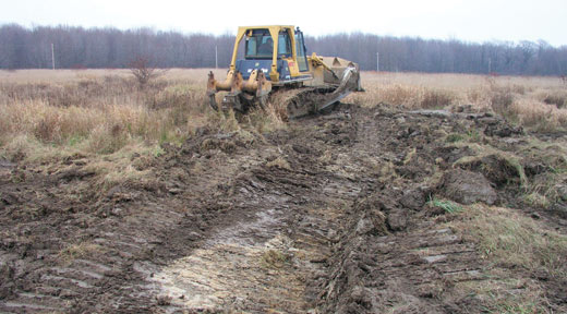
To disrupt water movement through the site, DRG created ruts, simulating naturally occuring hummocks that would have existed in the area pre-agriculture.
The Project
The Trumbull Creek Wetlands Mitigation Bank was approved in 2000 by the Mitigation Bank Review Team (MBRT). Phase 1A was completed and is nearing the end of the required five-year monitoring period. The second phase, which is being restored according to criteria set out in the more recently issued standards, is using vastly different hydrological and vegetative benchmarks. The Bank, which includes 462 acres, is located in Geauga and Ashtabula counties in northeast Ohio. Phase 1A includes 140 acres located primarily in Thompson Township, Geauga County. Work in Phase 2 , which includes the remaining 322 acres located in Thompson Township as well as Trumbull Township, Ashtabula County, got under way in 2004.
The Phase 1A restoration effort includes three separate wetlands cells, connected hydrologically by a system of large berms and water control structures, which captures surface water runoff and direct it to the adjacent wetlands creating large areas of deep water. As it comes to the end of the mandated monitoring period, the changes from pre-construction conditions are striking. The original performance standards for minimum acreage of diverse habitats, hydrology and plant diversity, and maximum performance standards for invasive plant species were met, but not enough for Phase II.
In Phase 2, earthwork at the site did not create the deep pools designed in Phase1A, but rather replicated the natural hummock/swale topography that is common to natural wetlands in northeastern Ohio. That earth moving effort was completed in late 2005 and massive replanting was launched in early 2006. Under the more stringent new standards, Phase 2 will be monitored for a ten-year period, rather than the standard two year review period under the old rules.
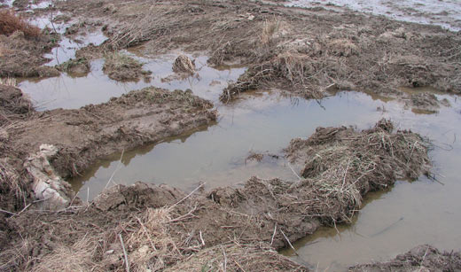
Depressions to collect and retard water movement were created by randomly roughing up the landscape.
Implementation
Phase 1A
At the end of the fourth year of monitoring, the 140 acres of Phase 1A now includes near 80 acres in wetlands that were created by DRG restoration efforts. An additional 45 acres are in vegetated open water, emergent marsh and lowland woods. Vegetation was encouraged by plantings in three successive years, but the underlying seed bank remaining from an earlier pre-agricultural period, contains native wetlands plants and is providing much of the vegetative growth.
Phase 2
Much like the natural plant communities in northeastern Ohio, the Trumbull Creek Phase 2 site contained a mix of wetlands in the depressions created by upturned trees and upland characteristics. The goal of the restoration is to create the hummock/ hollow landscape throughout the site. This was partially met by eliminating drainage swales and installing ditch plugs that coaxed the water to meander through the restoration area. Berms that had been part of the original design were flattened to limit the depth to three feet to which water could be impounded. This was critical, because limiting unvegetated open water to less than 10 percent of the total area is one benchmark by which success of the project will be measured.
To jumpstart the reforestation, during approximately three weeks in April 2006, as many as 40 workers installed a total of 90,000 bare root trees and shrubs in Trumbull Creek Phase 2. Covering an area of more than 176 acres of the mitigation site, 79,200 bare root seedlings were installed, encompassing almost the entire un-wooded portion of the restoration area at a density of 400 trees and 50 shrubs per acre. This included 58,080 wetland species of trees and 8,800 wetland shrubs. In addition to the wetland plants, 12,320 upland tree species were installed on the newly restored interspersed macro- and micro-topography. Cost was approximately $3,000 per acre planted, which included replanting and replacement during the first 3-growing seasons to achieve a 300-per-acre live density and other additional post planting maintenance and follow-up inspections.
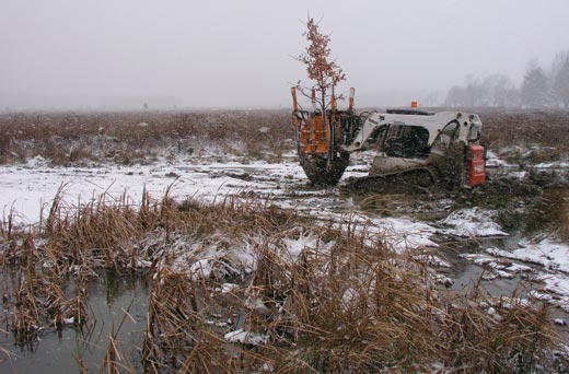
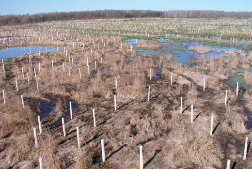
The early winter landscape revealed the mix of water-filled ruts, wetlands plants and the beginnings of forestation at the site.
Each of these bare root trees received two Repellex™ tablets at the time of installation. Repellex™ systemic tablets act as a repellent and slow release 14-2-2 fertilizer. Becoming systemic in the plant in four to six weeks, this product lasts up to two years. Made of some of the bitterest, non-toxic, biodegradable compounds, the systemic action in the treated plant will stop browsing by a number of herbivores including meadow voles, rabbits, and deer. To discourage competition from adjacent vegetation, each of these bare root trees will receive a 3x3-foot micro-site herbicide treatment for three consecutive years.
To further aid in tree and shrub establishment, over 35,200 4-foot Tubex® tree shelters and oak stakes were installed at a density of approximately 200 tubes per acre. The twin-walled, solid, light green, translucent tubes provide protection from animal browse and desiccating winds as well as creating a greenhouse environment that encourages seedling growth.
Included in the mix of bare root trees were larger plant material, some of these were balled and burlapped and included species such as Amelanchier laevis (smooth serviceberry), Aronia melanocarpa( black chokeberry), Cephalanthus occidentalis (common buttonbush), Quercus bicolor (swampwhite oak) and Quercus palustris (pin oak).
Another step in implementing Phase 2 of the wetlands was to not create pools of deeper water, but to replace them with small pockets, ruts and undulating topography hospitable to the vegetation associated with wetland and upland complexes, which will eventually result in a diverse forested wetland community.
Before the planting however, it was necessary to control the invasives including Phalaris arundinacea (reed canary grass), which was a legacy of the previous agriculture use of the land. It was controlled chemically on about 25 percent of the site with Rodeo®, an aquatic approved glyphosate herbicide. Further control of invasive plants will need to be selective to avoid damage to reforesting efforts, but each of the newly planted trees will be treated with a circle of herbicide until they become established.
By the end of the ten-year monitoring period, at least two-thirds of the area of Phase 2 should be re-established as forested wetlands. The goal for the remainder of the site is to restore emergent, shrub-dominated and/or sedge grass communities. Because of the time required for forest succession, the full forestation will not be evident at the end of the decade, but at least 60 percent of the area will be on a strong trajectory toward restoration to wetland swamp forest status. A measure of success is that at the end of ten years, an average of 100 woody plants will be thriving per acre.
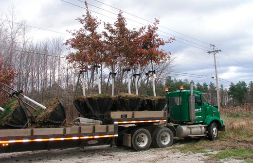
The larger trees were trucked to the site on a specially built semi-trailer in individual hydraulic tree pods from Davey's tree farm in Wooster, Ohio. The trees were removed from their travel pods and immediately spaded into their permanent locations.
Challenges
The staggering challenge put to the biologists of Davey Resource Group is to create in ten years a healthy start toward wetlands that has characteristics of one that has been developing over thousands of years. Because current monitoring standards measure success by the presence of climatic species rather than the successional colonizers that are found naturally in young wetland systems, biologists are essentially attempting to shortcut history. The mandate to move more quickly than nature is one that governs restoration efforts now, despite the fact that the validity of that approach will not be apparent for years.
Meeting the challenge is complicated by several factors. The most obvious is to anticipate the results of a process in which the variables are endless. Everything from the distribution of seeds by birds to the amount of water available from rainfall is part of the mix. And perhaps a more serious challenge is a socio-political one: the standards for what constitutes a successful restoration are changing. In the case of the Trumbull Creek Wetlands Mitigation Bank, the new guidelines were issued as the project was ongoing, requiring the biologists to rethink their approach even as they were in the midst of execution.
What’s Ahead
The monitoring for Phase 1A is nearly completed, but Phase 2 will continue to be evaluated for at least eight more years. As percentages of each of the criteria are met, acreage will be released for credits to be exchanged for wetlands destroyed elsewhere in the watershed. The release of credits is important on several fronts: both to make credits available to offset areas under development and to allow developers to recover some of costs they have fronted for mitigation projects. The pressure to make those credits available will be intense as the rapid loss of wetlands communities continues. And the challenge to create these areas in light of changing regulations will add increased pressure as well. ![]()
For more information, contact Pat Sarikelle, The Davey Tree Expert Company at (800)447-1667, ext. 326 or e-mail psarikelle@davey.com.