
Features Available Online
Grand River Bank Stabilization —
Applying Soft Engineering at a Large Scale
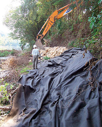
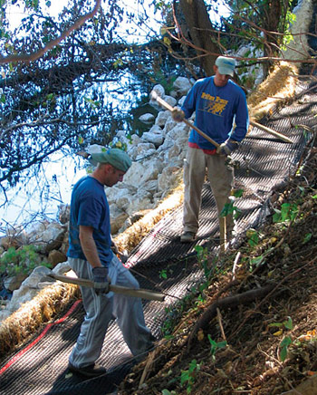
Left: Placement of rock toe over geotextile fabric. Right: Lift construction.
Introduction
The Grand River is the longest river in the state of Michigan, meandering 260 miles from its source in Jackson to its mouth at Lake Michigan in Grand Haven. On its way through the 5,572 square mile watershed, the river passes through a wide range of agricultural, urban, and undisturbed natural lands. As it nears the City of Grand Rapids, the river passes the world headquarters of Alticor, Inc. (Amway), a global manufacturer and distributor of various consumer products based in nearby Ada.
In the late 1990's, Alticor staff began to notice severe riverbank erosion along its approximately 1 mile of frontage. In this particular reach, the river level fluctuates as much as 8-10 feet seasonally and averages 51,317 cfs in flow. Approximately 2000 feet of the shoreline experienced moderate to severe erosion, with the worst 1000 feet showing a vertical face 6-10 feet in height. In addition to contributing large sediment loads to the Grand River--and eventually Lake Michigan--the eroding bank jeopardized the integrity of a 3 acre holding pond located nearby.
Alticor commissioned a series of studies in 2000 to address the erosion problem. Consistent with its commitment to good environmental stewardship, Alticor required any proposed design to provide a natural, ecologically sustainable solution to the problem.
In 2004, the company selected ecological consulting firm JFNew as the lead design engineer based on their extensive experience with using natural systems for streambank stabilization.
Design and Permitting
The engineer initiated the design in late 2004 by reviewing previous studies and performing an inspection of the riverbank. Construction was scheduled for completion during August and September 2005, to take advantage of low river levels. The company identified several key issues impacting the project at the time:
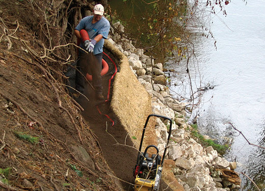
Backfilling lift with blown soil.
- Public involvement and notification would be important due to the high profile of the project and Alticor's commitment to helping the community and environment
- Obtaining state and local permitting would be challenging due to the significant amount of fill that would have to be placed in the floodway in order to properly stabilize the bank.
- Access to the riverbank was limited to a very narrow berm along the shore with numerous mature trees on it, or via the river itself.
With these issues in mind, the JFNew and Alticor team collaborated on a series of conceptual designs to meet both the functional and environmental goals of the project. After reviewing the designs and associated budgets, they selected a technique using several tiered soil "lifts" placed on top of a rock toe, then planted with native grasses and shrubs.
The team conducted a site survey and measured cross sections of the river, which is as wide as 450' at the project location. While project engineers developed detailed plans and HEC-RAS models necessary for permitting and construction, the team met with the local township and Michigan Department of Environmental Quality (MDEQ) to discuss permits. Additionally, a public information session was held at the local township hall to answer questions associated with the project. Chuck Davison, Alticor project manager, explained "...another plus was the proactive approach we took together in meeting with regulatory agencies and the general public ahead of permit application submittal. We explained the project, addressed concerns, and were successful in obtaining the necessary approvals—not just approvals—but also acceptance and buy-in on the design."
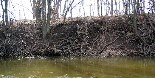
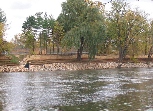
Top: Riverbank pre-construction. Bottom: Riverbank postconstruction.
While the MDEQ was supportive of the project, Michigan regulations require mitigation for any floodplain fill quantity over 300 cubic yards. This stabilization project would require placement of 2,025 cubic yards of fill along the riverbank.
Davison came up with a unique solution to the floodplain fill. He explained to MDEQ and township officials that one year earlier, Alticor created stormwater retention lagoons on its property along the river that effectively provided additional floodplain storage. MDEQ considered new retention lagoons to be adequate mitigation for the floodplain fill, avoiding the need for additional excavation as part of the riverbank stabilization project.
With permitting issues resolved, the design process continued. The basis for the final design was a rock toe that followed the contour of the existing shoreline with fabric-encapsulated soil lifts above, planted densely with native vegetation. Angular 8"-18" stone would be placed no more than 3 feet from the bank on a base of 7 oz. non-woven geotextile fabric. The toe extended 5 feet above the river bottom.
On top of the stone base, a series of four 18" soil lifts would be constructed. The outer layer of each lift would be made of Rolanka Bio-ND TRM-100 jute fabric. Inside the jute fabric was a layer of straw-coconut erosion blanket. These fabrics would be placed over the lift form, then filled with 12" of soil fill. After compaction, a layer of Synteen SF-55 geogrid would be placed over the soil and staked into the bank using 3' hardwood stakes.
The remaining fill would then be placed to a total height of 18" and seeded with native species before completing the "wrap" by folding the remaining fabric over the seeded soil. Plant species were chosen based on species native to stable riverbanks in the area, and included riverbank wild rye (Elymus riparius), prairie cord grass (Spartina pectinata), Virginia wild rye (Elymus virginicus), and common wood reed (Cinna arundinacea).
The design also incorporated native shrubs for additional stability. One-gallon potted shrubs were placed in between the lift layers and would include red-oser dogwood (Cornus sericea), silky dogwood (Cornus obliqua), and nannyberry (Viburnum lentago).
The stone at the base would keep the riverbank from eroding at the toe, while the lifts would provide structure and native plants to lock the shoreline together while providing habitat, thus "fortifying" nature.
Construction
Alticor selected JFNew as general contractor for constructing the stabilization system because of their extensive experience designing and building similar systems. The original plan for construction access by river called for use of a shallow barge to place the stone and fill material along the riverbank. This technique would minimize disturbance along the bank and avoid the need to move heavy equipment along the narrow berm.
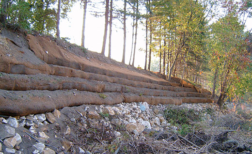
Riverbank immediately following construction in November, 2005.
As the summer progressed and river levels fell, a new problem emerged. Because of an especially dry year, the river was too low for barge access. August water levels were less than 1' in many places, making barge access impossible.
Seeking other methods of site access, the project team called in Katerberg-Verhage, a local landscape/construction firm, to explore unobtrusive ways to place stone without destroying the trees along the berm. By slightly widening the back side of the berm, Katerberg-Verhage thought they could place the stone in between the trees, avoiding significant clearing or grubbing.
With the stone set, the team pondered how to place the soil into the lifts. Soil placement would have to be a nimble operation to avoid leaving soil in the river or destroying any already constructed lifts. On other similar projects, JFNew had utilized a compost/mulch blowing truck to place material on sites like these. After consulting Mulch Plus, it was determined that their truck could access the berm and blow the required soil blend into the lifts.
The new construction team was now set: Katerberg-Verhage placing the stone, JFNew constructing the lifts and installing plant material, and Mulch Plus blowing soil into the lifts.
Work began in early September 2005 and lasted approximately 8 weeks -- with few delays due to adverse weather. After resolving some of the logistical challenges, project construction was completed on time and on budget, costing approximately $200/linear ft.
Conclusion
Since completion, the Grand River in Ada has flooded multiple times to heights near the top of the stabilized riverbank. While some minor slumping has occurred, which is typical of the installed system, no major failures have occurred along the riverbank. The native vegetation has grown thicker during each of the two growing seasons since installation, binding the soil while providing habitat along the riverbank.
"In the end," said Brian Majka, project manager for JFNew, "we were able to demonstrate that green engineering can work with large river systems as well as smaller streams. All of the principles are the same, they just get applied at a larger scale." From Alticor's perspective, "Our expectations of functionality and a positive environmental impact were both exceeded."
![]()
For more information, contact Brian Majka, Restoration Unit Manager, JFNew, 11181 Marwill Ave., West Olive, MI 49460 (616)847-1680, Fax: 616-847-9970, or Email: bmajka@jfnew.com.